نیارش گستر ایران
ساختن دست یافتنی است!نیارش گستر ایران
ساختن دست یافتنی است!زمینلرزه ۱۳۹۶ ازگله - 2017 Iran–Iraq earthquake
زمینلرزه ۱۳۹۶ ازگله
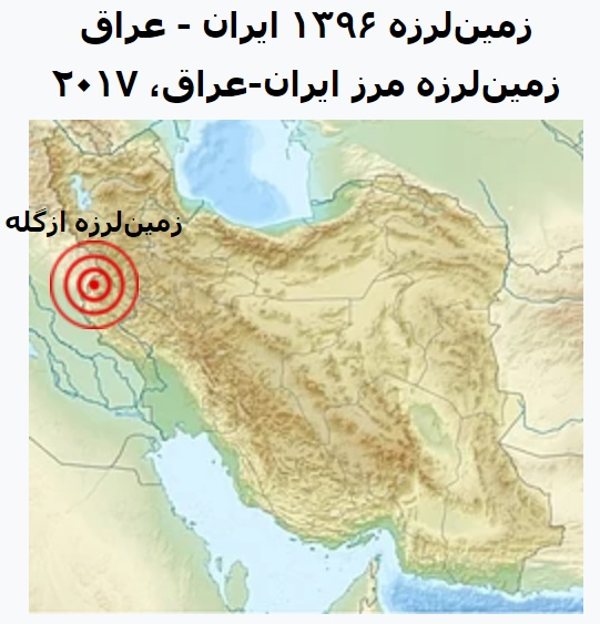
زمینلرزه ۱۳۹۶ ایران - عراق به بزرگی ۷٫۳ در مقیاس بزرگای گشتاوری شامگاه یکشنبه ۲۱ آبان ۱۳۹۶ در نزدیکی ازگله، استان کرمانشاه در نزدیکی مرز ایران و عراق، در ۳۲ کیلومتری جنوب غربی شهر حلبچه عراق رخ داد.
کانون زمینلرزه ۵ کیلومتری شهر ازگله کرمانشاه بود و زلزله نگاری آمریکا کانون این زلزله را ۳۲ کیلومتری حومه شهر عراقی حلبچه اعلام کرد.
بر طبق گفته رئیس مرکز لرزهنگاری ایران چندین پیش لرزه قبل از زلزله ۷٫۳ ریشتری حوالی ساعت ۲۱ تا ۲۱:۴۸ اتفاق افتاده که موجب هشیاری مردم شد که بزرگترین این پیش لرزهها به قدرت ۴/۵ ریشتر ثبت شد. تعداد کشتهها در ایران به ۶۲۰ نفر رسید. و همچنین ۹٬۳۸۸ نفر نیز زخمی شدهاند و حدود ۷۰٬۰۰۰ نفر بیخانمان شدند.
شهر ازگله نزدیکترین شهر به کانون زلزله (۵ کیلومتر) بود. عمق زمین لرزه ۱۱ کیلومتر بوده که به علت عمق کم و مدت زیاد در کل منطقه شمال غرب کشور احساس شد. این زلزله در جنوب شرق ترکیه و حتی کویت و شمال عربستان سعودی هم احساس شدهاست. برخی رسانههای اسرائیلی خبر از حس شدن این زمینلرزه در بخشهای وسیعی از اسرائیل دادند. تا روز ۱ آذر ماه سال ۱۳۹۶ حدود ۷۰۰ پسلرزه استان کرمانشاه را لرزاندهاست.
کانون زلزله
کانون زمینلرزه ۵ کیلومتری شهر ازگله از توابع استان کرمانشاه است؛ و عمق این زمینلرزه ۱۱ کیلومتری زمین گزارش شدهاست.
بنا به گزارش زلزله نگاری آمریکا کانون این زلزله در ۳۲ کیلومتری حومه شهر عراقی حلبچه و عمق زلزله ۳۳٫۹ کیلومتری از سطح زمین بودهاست.
کانون زمین لرزه شهر ازگله (بین شهرهای قصرشیرین و سرپلذهاب) بوده است.
مشخصات:
تاریخ و زمان وقوع به وقت محلی: ۱۳۹۶/۰۸/۲۱ ۲۱:۴۸:۱۶
طول جغرافیایی: ۴۵٫۹
عرض جغرافیایی: ۳۴٫۸۴
عمق زمین لرزه: ۱۱ کیلومتر
نزدیکترین شهرها:
۵ کیلومتری ازگله (کرمانشاه)
۲۵ کیلومتری تازه آباد (کرمانشاه)
۳۷ کیلومتری باینگان (کرمانشاه)
نزدیکترین مراکز استان:
۱۱۲ کیلومتری سنندج
۱۲۲ کیلومتری کرمانشاه
2017 Iran–Iraq earthquake
On 12 November 2017 at 18:18 UTC (21:48 Iran Standard Time, 21:18 Arabia Standard Time), an earthquake with a moment magnitude of 7.3 occurred on the Iran–Iraq border, with the Iraqi Kurdish city of Halabja, and the Kurdish dominated places of Ezgeleh, Salas-e Babajani County, Kermanshah Province in Iran, closest to the epicentre, 30 kilometres (19 mi) south of the city of Halabja, Iraqi Kurdistan.
It was felt as far away as Israel and the United Arab Emirates. With at least 630 people killed (mostly in Iraq's Kurdish Halabja area and the Iranian Kurdish dominated province of Kermanshah), and more than 8,100 injured, as well as many more unaccounted for, it was the deadliest earthquake of 2017.
Tectonic setting
The earthquake was located within the Zagros fold and thrust belt, part of the broad and complex zone of continental collision between the Arabian and Eurasian Plates. At this location, the relative convergence of the plates is about 26 mm per year.[4] The convergence is quite oblique to the Zagros belt, although it is partitioned into orthogonal dip-slip motion within the active thrust belt and dextral (right lateral) strike-slip motion along the Main Recent Fault to the northeast of the Zagros Mountains.
Earthquake
The earthquake occurred near the Iran–Iraq border, approximately 220 kilometres (140 mi) northeast of Baghdad.According to the United States Geological Survey, the earthquake measured 7.3 on the moment magnitude scale and was caused by movement on a thrust fault dipping at a shallow angle to the northeast. The epicentre was at a depth of 19.0 kilometres (11.8 mi), and the maximum perceived intensity was VIII (severe shaking) on the Mercalli intensity scale.
This was the strongest earthquake recorded in the region since a 6.1 Mw event in January 1967. The earthquake was felt throughout the Middle East and as far away as Israel, the Arabian Peninsula and Turkey. The Iranian seismological centre registered at least 50 aftershocks within a few hours of the earthquake. Read More In The Next Post.
با ادامه این مطلب در پست بعدی همراه ما باشید