نیارش گستر ایران

ساختن دست یافتنی است!

نیارش گستر ایران

ساختن دست یافتنی است!

قدرت زلزله بر اساس ریشتر - Intensity of an Earthquake based on Richter Scales

زیر 2 ریشتر: غیر قابل احساس توسط انسان/ تنها توسط دستگاه ثبت می شود/ میلیون ها بار در سال در کره زمین می آید و امری مستمر است.

2 تا 3 ریشتر:
اکثر انسان ها قادر به احساس آن نیستند و فقط اشیاء معلق، تکان مختصری می خورند./ سالانه 300 هزار زلزله 2 الی 3 ریشتری در کره زمین رخ می دهد.

3 تا 4 ریشتر:
وقتی در خانه اید احساس می کنید یک کامیون سنگین از پشت دیوار خانه رد می شود/ سالانه 49 هزار بار در کل جهان می آید.

4 تا 5 ریشتر:
اکثر مردم آن را احساس می کنند، اشیاء داخل ساختمان به لرزش در می آیند، در و پنجره ها باز و بسته می شوند؛ معمولا تلفات ندارد مگر افرادی که دچار وحشت شده اند یا حین فرار آسیب می بینند/ 6300 بار در سال رخ می دهد.

5 تا 6 ریشتر:
همه مردم آن را احساس می کنند، کمدها و اشیاء سنگین داخل خانه تکان می خورند، کنترل خودرو حین رانندگی سخت می شود، خانه های سست فرو می ریزند و عده ای زیر آوار می مانند./ در جهان سالانه 800 بار رخ می دهد.

6 تا 7 ریشتر:
ساختمان هایی که در برابر زلزله مقاوم نیستند فرو می ریزند، برخی ساختمان های مقاوم نیز دچار آسیب هایی می شوند و تلفات انسانی به بار می آید.

7 تا 8 ریشتر:

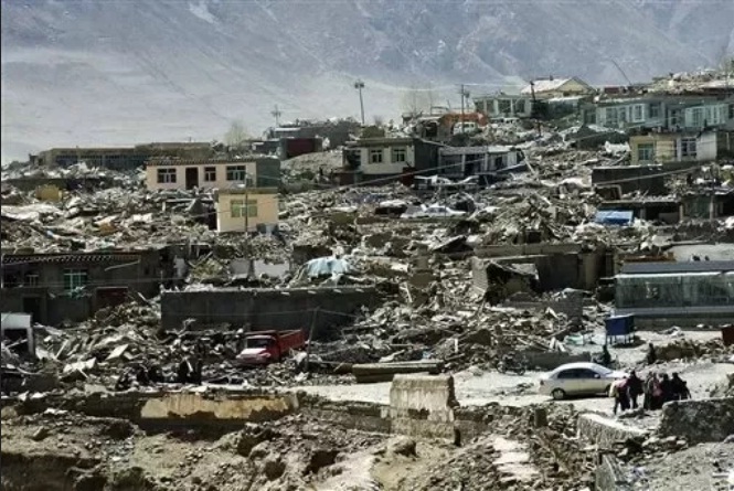
اغلب ساختمان ها فرو می ریزند، حتی ساختمان های موسوم به ضد زلزله هم خسارت هایی را متحمل می شوند، تلفات انسانی گسترده است و به دلیل فروریختن آوار در معابر، امداد رسانی مشکل خواهد بود.سیستم های خدمات شهری مانند لوله کشی آب و گاز و نیز برق قطع می شود و حتی امکان دارد آتش سوزی هم رخ دهد./ سالانه حدود 18 زلزله 7 تا 8 ریشتری در جهان رخ می دهد.

8 تا 10 ریشتر:

تخریب کامل، کشتار وسیع و تغییر شکل دائمی زمین در محل وقوع/ اگر کانون زمین لرزه در دریا و اقیانوس باشد، سونامی شکل می گیرد و شهرهای ساحلی اطراف را منهدم می کند/ به ندرت اتفاق می افتد

زلزله 10 ریشتری:
تا کنون ثبت نشده است ولی دانشمندان ژاپنی می گویند وقوع آن در 10 هزار سال آینده محتمل است که اگر بیاید، کل زمین یک ساعت خواهد لرزید و بخش اعظم خشکی ها زیر آب می روند و کاملاً نابود می شوند.

توجه داشته باشید که هر یک واحد که زلزله قوی تر می شود، قدرت تخریب آن به طور تصاعدی بالا می رود (که تا 31 برابر هم گفته اند). به همین دلیل است که زلزله 2 ریشتری قدرتی کمتر از انفجار 45 کیلوگرم تی ان تی دارد ولی زلزله 7 تا 8 ریشتری، معادل انفجار 100 بمب هیدروژنی انرژی آزاد می کند.


درباره قدرت زلزله بر اساس ریشتر چه می دانید؟
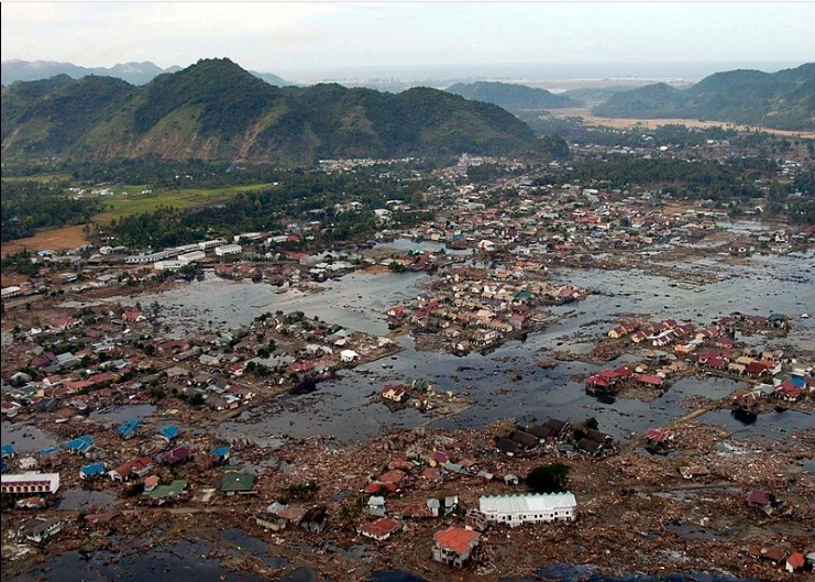

زمین‌لرزه و سونامی ۲۰۰۴ اقیانوس هند - 2004 Indian Ocean earthquake and tsunami

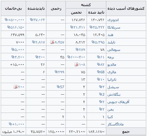
زلزلهٔ بزرگ اندونزی در مورخه ۲۶ دسامبر ۲۰۰۴ میلادی مطابق با ۶ دی ماه ۱۳۸۳ با بزرگای گشتاوری ۹/۱ ریشتر در عمق ۳۰ کیلومتری زمین و در فاصله ۱۶۰ کیلومتری شمال غرب سواحل سوماترای اندونزی درون اقیانوس هند اتفاق افتاد. این زمین لرزه سومین زلزله قدرتمند ثبت شده تاریخ و طولانی‌ترین زمین لرزه نام گرفت که به مدت ده دقیقه مناطق اطراف را به لرزه درآورد. آبلرزه حاصل از این زلزله باعث مرگ بیش از ۲۸۶۰۰۰ نفر در ۱۴ کشور گوناگون شد. یکی از مناطقی که با وجود فاصله زیاد از مرکز لرزه آسیب‌های جدی دیده بندر بیلا می‌باشد.

کشورهای آسیب دیده

در این حادثه کشورهای زیادی آسیب‌های جانی و مالی فراوانی را متحمل شدند که بیشتر شامل کشورهایی با وضعیت بد اقتصادی می‌شود. آماری از آسیب‌های وارده به این کشورها در جدول زیر آمده‌است.
منبع: ویکی پدیا
The 2004 Indian Ocean earthquake and tsunami (also known as the Boxing Day Tsunami) occurred at 00:58:53 UTC on 26 December, with an epicentre off the west coast of northern Sumatra, Indonesia. It was an undersea megathrust earthquake that registered a magnitude of 9.1–9.3 Mw, reaching a Mercalli intensity up to IX in certain areas. The earthquake was caused by a rupture along the fault between the Burma Plate and the Indian Plate.
A series of massive tsunami waves grew up to 30 metres (100 ft) high once heading inland, after being created by the underwater seismic activity offshore. Communities along the surrounding coasts of the Indian Ocean were severely affected, and the tsunamis killed an estimated 227,898 people in 14 countries. The Indonesian city of Banda Aceh reported the largest number of victims. The earthquake was one of the deadliest natural disasters in recorded history. The direct results caused major disruptions to living conditions and commerce, particularly in Indonesia, Sri Lanka, India, and Thailand.
The earthquake was the third-largest ever recorded and had the longest duration of faulting ever observed; between eight and ten minutes. It caused the planet to vibrate as much as 10 millimetres (0.4 inches), and it remotely triggered earthquakes as far away as Alaska. Its epicentre was between Simeulue and mainland Sumatra. The plight of the affected people and countries prompted a worldwide humanitarian response, with donations totalling more than US$14 billion. The event is known by the scientific community as the Sumatra–Andaman earthquake.

Earthquake

The 2004 Indian Ocean earthquake was initially documented as having a moment magnitude of 8.8. In February 2005, scientists revised the estimate of the magnitude to 9.0. Although the Pacific Tsunami Warning Center has accepted these new numbers, the United States Geological Survey has so far not changed its estimate of 9.1. A 2006 study estimated a magnitude of Mw 9.1–9.3; Hiroo Kanamori of the California Institute of Technology estimates that Mw  9.2 is representative of the earthquake's size.
The hypocentre of the main earthquake was approximately 160 km (100 mi) off the western coast of northern Sumatra, in the Indian Ocean just north of Simeulue island at a depth of 30 km (19 mi) below mean sea level (initially reported as 10 km or 6.2 mi). The northern section of the Sunda megathrust ruptured over a length of 1,300 km (810 mi). The earthquake (followed by the tsunami) was felt in Bangladesh, India, Malaysia, Myanmar, Thailand, Sri Lanka and the Maldives. Splay faults, or secondary "pop up faults", caused long, narrow parts of the seafloor to pop up in seconds. This quickly elevated the height and increased the speed of waves, destroying the nearby Indonesian town of Lhoknga.
Indonesia lies between the Pacific Ring of Fire along the north-eastern islands adjacent to New Guinea, and the Alpide belt that runs along the south and west from Sumatra, Java, Bali, Flores to Timor. The 2002 Sumatra earthquake is believed to have been a foreshock, preceding the main event by over two years.
Great earthquakes, such as the 2004 Indian Ocean earthquake, are associated with megathrust events in subduction zones. Their seismic moments can account for a significant fraction of the global seismic moment across century-scale periods. Of all the moment released by earthquakes in the 100 years from 1906 through 2005, roughly one-eighth was due to the 2004 Indian Ocean earthquake. This quake, together with the Good Friday earthquake (Alaska, 1964) and the Great Chilean earthquake (1960), account for almost half of the total moment.
Since 1900, the only earthquakes recorded with a greater magnitude were the 1960 Great Chilean earthquake (Magnitude 9.5) and the 1964 Good Friday earthquake in Prince William Sound (Magnitude 9.2). The only other recorded earthquakes of magnitude 9.0 or greater were off Kamchatka, Russia, on 4 November 1952 (magnitude 9.0) and Tōhoku, Japan (magnitude 9.1) in March 2011. Each of these megathrust earthquakes also spawned tsunamis in the Pacific Ocean. In comparison to the 2004 Indian Ocean earthquake, the death toll from these earthquakes was significantly lower, primarily because of the lower population density along the coasts near affected areas, the much greater distances to more populated coasts, and the superior infrastructure and warning systems in MEDCs (More Economically Developed Countries) such as Japan.Other huge megathrust earthquakes occurred in 1868 (Peru, Nazca Plate and South American Plate); 1827 (Colombia, Nazca Plate and South American Plate); 1812 (Venezuela, Caribbean Plate and South American Plate) and 1700 (western North America, Juan de Fuca Plate and North American Plate).  All of them are believed to be greater than magnitude 9, but no accurate measurements were available at the time.

روستایی در ساحل سوماترا، اندونزی