نیارش گستر ایران
ساختن دست یافتنی است!نیارش گستر ایران
ساختن دست یافتنی است!وحشتناک ترین فیلم واقعی از سونامی ژاپن که تا کنون دیده نشده - The most terrifying real Japanese tsunami footage ever seen
پس از این زمین لرزه بود که نائوتو کان، نخست وزیر وقت ژاپن از آن به عنوان بدترین و سختترین بحران ژاپن پس از پایان جنگ جهانی دوم یاد کرد.
۱۱ مارس ۲۰۱۱ بود که زمینلرزهای به قدرت ۹ ریشتر در نزدیکی سندای در استان میاگی در شمال شرقی ژاپن رخ داد. مرکز سطحی زمینلرزه ناحیهٔ توکوهو بود. این زمینلرزه موجب خسارات بسیار زیادی شامل تخریب شدید جادهها، راهآهن، ایجاد آتشسوزی در برخی مناطق در ژاپن شد.
پس از این زمین لرزه برق حدود ۴٫۴ میلیون خانوار در شمال شرقی ژاپن قطع شد و ۱٫۴ میلیون نفر نیز از دسترسی به آب آشامیدنی محروم شدند. همچنین منفجر شدن سه راکتور هستهای در پی انباشته شدن گاز هیدروژن موجب از کار افتادن تعدادی از ژنراتورهای الکتریکی در این کشور شد. پس از این زمین لرزه بود که نائوتو کان، نخست وزیر وقت ژاپن از آن به عنوان بدترین و سختترین بحران ژاپن پس از پایان جنگ جهانی دوم یاد کرد.
اما این زمینلرزه تمام ماجرا نبود. پس از وقوع این زمین لرزه بزرگ یک سونامی عظیم در برخی نواحی ژاپن ایجاد شد. امواج این سونامی بزرگ و بیسابقه در ژاپن به ارتفاع ۱۵ متر میرسید. بلافاصله در ژاپن بالاترین درجه هشدار خطر سونامی اعلام شد و توسط بلندگوها و رادیو و تلویزیون از مردم خواسته شد که به سرعت نواحی نزدیک دریا را تخلیه کرده و به نواحی بلند پناه ببرند.
اثرات این سونامی مرگبارتر و مخربتر از زمینلرزه بود. تصاویر پس از سونامی شهر مینامیسانریکو نشان میداد که هیچ آثاری از وجود شهر باقی نمانده است. در شهر ریکوزنتاکاتا نیز تا طبقهٔ سوم ساختمانها به زیر آب فرو رفتند. خسارت در سه استان فوکوشیما، میاگی و ایواته ژاپن بسیار گسترده بود. بنا بر اعلام آژانس پلیس ملی ژاپن در اثر این زمین لرزه مهیب و سونامی بزرگ ۴۵۷۰۰ ساختمان نابود شد و به ۱۴۴۳۰۰ ساختمان نیز خسارت وارد شد. همچنین به ۲۳۰۰۰۰ خودرو و کامیون نیز خسارت وارد شد. در ادامه میتوانید ویدئوی تکان دهنده از این سونامی وحشتناک را مشاهده کنید.
The most devastating Earthquake in Japan
سونامی شهر مینامیسانریکو
نیارش گستر ایران - Niaresh Gostar Iran
سونامی چیست؟ What is Tsunami
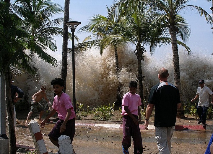
امواج کشندی یا آبتاز، آبلرزه یا سونامی ( Tsunami) یکی از بلایای طبیعی است. سونامی به لرزش شدید آب دریا گفته میشود که در پی زمینلرزههای زیر دریا پدید میآید. آبی که به لرزه درآمده بهشکل موجهای عظیم به کرانهها رسیده و ویرانی به بار میآورَد. سونامی موقعی شروع میشود که حجم عظیمی از آب به سرعت مرتفع میشود. این حرکتِ سریع میتواند در نتیجهٔ یک زلزلهٔ زیرآبی رخ دهد یا بر اثر لغزیدن صخره، یا یک انفجار آتشفشانی یا هر حادثهٔ دیگری که انرژی زیادی دارد ایجاد شود.
واژهشناسی
بسیاری از سونامیها در کرانههای ژاپن رخ میدهند و از این رو واژه Tsunami مربوط به این پدیده یعنی (سونامی) به انگلیسی و از آن راه به بسیاری زبانهای دیگر نیز راه یافته است. غریاله واژهٔ فارسی بومی برای این پدیده در استان بوشهر است. و پدیدهٔ غریاله در کرانههای خلیج فارس دارای پیشینه است.
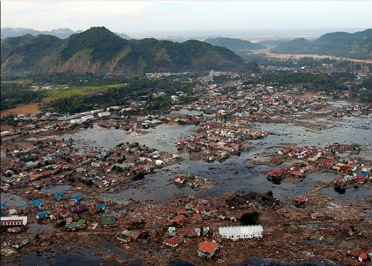
سونامیها معمولاً پس از یک زمینلرزهٔ بزرگ (با حرکت رو به بالا)، فعالیت آتشفشانی زمینلغزه یا برخورد شهابسنگها پدید میآیند. پس از سونامیها معمولاً گسلهای بزرگی در بستر دریاها پدید میآیند. سرعت موجهای آبلرزهای گاه به بیش از ۸۰۰ کیلومتر در ساعت میرسد. سونامی سال ۱۷۸۸ لیسبون (پرتغال) با موجهایی به بلندی حدود ۱۸ متر به شهر هجوم برد و ساکنان آن شهر را در کام خود فروبرد. یکی از بزرگترین سونامیها که در دسامبر سال ۲۰۰۴ میلادی در نزدیکی سوماترای اندونزی روی داد باعث ویرانی عظیم و کشته شدن پیرامون ۱۰۰٫۰۰۰ تن در جنوب آسیا شد.
در کتابهای تاریخ آمده که بندر بزرگ و پهناور سیراف در جنوب ایران تا سدهٔ چهارم هجری و عصر دیلمیان بندری آباد و پررونق بوده و ناگهان بر اثر زمینلرزهای، قسمت بزرگی از شهر به زیر آب رفته که آثار آن هنوز هم مورد توجه باستانشناسان ایرانی و خارجی است. آیا غریاله سیراف را ویران کرد و به زیر آب برد پاسخ این سؤال را باید در پژوهشهای آینده یافت.
A tsunami lit. 'harbour wave' pronounced [tsɯnami]) is a series of waves in a water body caused by the displacement of a large volume of water, generally in an ocean or a large lake. Earthquakes, volcanic eruptions and other underwater explosions (including detonations, landslides, glacier calvings, meteorite impacts and other disturbances) above or below water all have the potential to generate a tsunami. Unlike normal ocean waves, which are generated by wind, or tides, which are generated by the gravitational pull of the Moon and the Sun, a tsunami is generated by the displacement of water.
Tsunami waves do not resemble normal undersea currents or sea waves because their wavelength is far longer. Rather than appearing as a breaking wave, a tsunami may instead initially resemble a rapidly rising tide. For this reason, it is often referred to as a tidal wave, although this usage is not favoured by the scientific community because it might give the false impression of a causal relationship between tides and tsunamis. Tsunamis generally consist of a series of waves, with periods ranging from minutes to hours, arriving in a so-called "wave train". Wave heights of tens of metres can be generated by large events. Although the impact of tsunamis is limited to coastal areas, their destructive power can be enormous, and they can affect entire ocean basins. The 2004 Indian Ocean tsunami was among the deadliest natural disasters in human history, with at least 230,000 people killed or missing in 14 countries bordering the Indian Ocean.
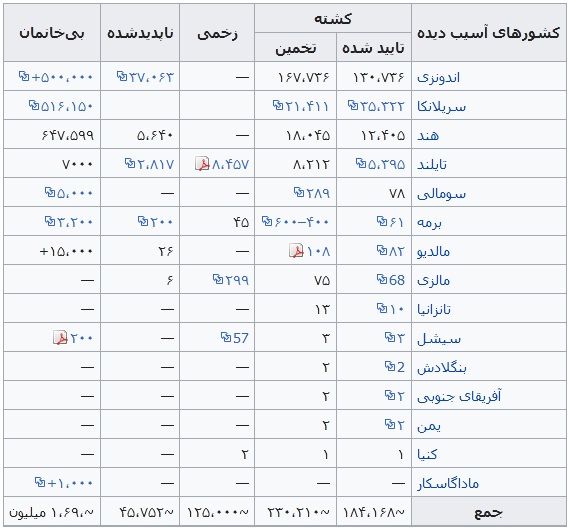
زمینلرزه و سونامی ۲۰۰۴ اقیانوس هند - 2004 Indian Ocean earthquake and tsunami
زلزلهٔ بزرگ اندونزی در مورخه ۲۶ دسامبر ۲۰۰۴ میلادی مطابق با ۶ دی ماه ۱۳۸۳ با بزرگای گشتاوری ۹/۱ ریشتر در عمق ۳۰ کیلومتری زمین و در فاصله ۱۶۰ کیلومتری شمال غرب سواحل سوماترای اندونزی درون اقیانوس هند اتفاق افتاد. این زمین لرزه سومین زلزله قدرتمند ثبت شده تاریخ و طولانیترین زمین لرزه نام گرفت که به مدت ده دقیقه مناطق اطراف را به لرزه درآورد. آبلرزه حاصل از این زلزله باعث مرگ بیش از ۲۸۶۰۰۰ نفر در ۱۴ کشور گوناگون شد. یکی از مناطقی که با وجود فاصله زیاد از مرکز لرزه آسیبهای جدی دیده بندر بیلا میباشد.
کشورهای آسیب دیده
Earthquake
زمینلرزه ۱۹۶۰ والدیویا، شیلی- 1960 Valdivia earthquake
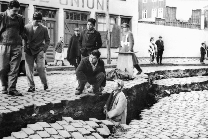
زمینلرزهٔ ۱۹۶۰ والدیویا یا زمینلرزهٔ عظیم شیلی در تاریخ ۲۲ مه ۱۹۶۰ میلادی، برابر با ۱ خرداد ۱۳۳۹، ساعت ۱۹:۱۱:۱۷ به زمان یوتیسی در شیلی، منطقه والدیویا رخ داد. این زمینلرزه قدرتمندترین زمینلرزهٔ ثبت شده در تاریخ است. ژرفای این زلزله ۳۵ کیلومتر و بزرگی آن ۹٫۶ در مقیاس Mw اعلام شدهاست. زمینلرزه به وقت محلی در روز یکشنبه، ساعت ۱۵ روی داده و منطقه زمانی آن یوتیسی -۴ بودهاست (با لحاظ تغییر ساعت تابستانی).