نیارش گستر ایران
ساختن دست یافتنی است!نیارش گستر ایران
ساختن دست یافتنی است!سونامی چیست؟ What is Tsunami
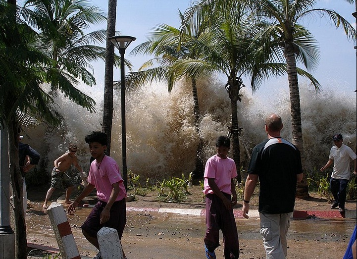
امواج کشندی یا آبتاز، آبلرزه یا سونامی ( Tsunami) یکی از بلایای طبیعی است. سونامی به لرزش شدید آب دریا گفته میشود که در پی زمینلرزههای زیر دریا پدید میآید. آبی که به لرزه درآمده بهشکل موجهای عظیم به کرانهها رسیده و ویرانی به بار میآورَد. سونامی موقعی شروع میشود که حجم عظیمی از آب به سرعت مرتفع میشود. این حرکتِ سریع میتواند در نتیجهٔ یک زلزلهٔ زیرآبی رخ دهد یا بر اثر لغزیدن صخره، یا یک انفجار آتشفشانی یا هر حادثهٔ دیگری که انرژی زیادی دارد ایجاد شود.
واژهشناسی
بسیاری از سونامیها در کرانههای ژاپن رخ میدهند و از این رو واژه Tsunami مربوط به این پدیده یعنی (سونامی) به انگلیسی و از آن راه به بسیاری زبانهای دیگر نیز راه یافته است. غریاله واژهٔ فارسی بومی برای این پدیده در استان بوشهر است. و پدیدهٔ غریاله در کرانههای خلیج فارس دارای پیشینه است.
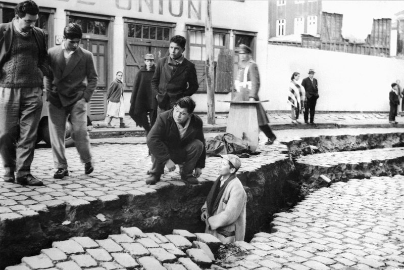
سونامیها معمولاً پس از یک زمینلرزهٔ بزرگ (با حرکت رو به بالا)، فعالیت آتشفشانی زمینلغزه یا برخورد شهابسنگها پدید میآیند. پس از سونامیها معمولاً گسلهای بزرگی در بستر دریاها پدید میآیند. سرعت موجهای آبلرزهای گاه به بیش از ۸۰۰ کیلومتر در ساعت میرسد. سونامی سال ۱۷۸۸ لیسبون (پرتغال) با موجهایی به بلندی حدود ۱۸ متر به شهر هجوم برد و ساکنان آن شهر را در کام خود فروبرد. یکی از بزرگترین سونامیها که در دسامبر سال ۲۰۰۴ میلادی در نزدیکی سوماترای اندونزی روی داد باعث ویرانی عظیم و کشته شدن پیرامون ۱۰۰٫۰۰۰ تن در جنوب آسیا شد.
در کتابهای تاریخ آمده که بندر بزرگ و پهناور سیراف در جنوب ایران تا سدهٔ چهارم هجری و عصر دیلمیان بندری آباد و پررونق بوده و ناگهان بر اثر زمینلرزهای، قسمت بزرگی از شهر به زیر آب رفته که آثار آن هنوز هم مورد توجه باستانشناسان ایرانی و خارجی است. آیا غریاله سیراف را ویران کرد و به زیر آب برد پاسخ این سؤال را باید در پژوهشهای آینده یافت.
A tsunami lit. 'harbour wave' pronounced [tsɯnami]) is a series of waves in a water body caused by the displacement of a large volume of water, generally in an ocean or a large lake. Earthquakes, volcanic eruptions and other underwater explosions (including detonations, landslides, glacier calvings, meteorite impacts and other disturbances) above or below water all have the potential to generate a tsunami. Unlike normal ocean waves, which are generated by wind, or tides, which are generated by the gravitational pull of the Moon and the Sun, a tsunami is generated by the displacement of water.
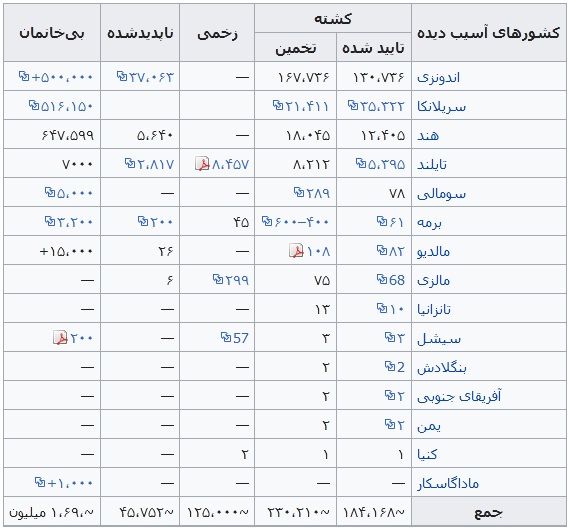
Tsunami waves do not resemble normal undersea currents or sea waves because their wavelength is far longer. Rather than appearing as a breaking wave, a tsunami may instead initially resemble a rapidly rising tide. For this reason, it is often referred to as a tidal wave, although this usage is not favoured by the scientific community because it might give the false impression of a causal relationship between tides and tsunamis. Tsunamis generally consist of a series of waves, with periods ranging from minutes to hours, arriving in a so-called "wave train". Wave heights of tens of metres can be generated by large events. Although the impact of tsunamis is limited to coastal areas, their destructive power can be enormous, and they can affect entire ocean basins. The 2004 Indian Ocean tsunami was among the deadliest natural disasters in human history, with at least 230,000 people killed or missing in 14 countries bordering the Indian Ocean.
زمینلرزه و سونامی ۲۰۰۴ اقیانوس هند - 2004 Indian Ocean earthquake and tsunami
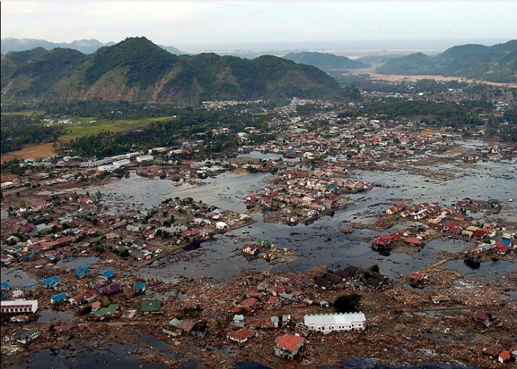
زلزلهٔ بزرگ اندونزی در مورخه ۲۶ دسامبر ۲۰۰۴ میلادی مطابق با ۶ دی ماه ۱۳۸۳ با بزرگای گشتاوری ۹/۱ ریشتر در عمق ۳۰ کیلومتری زمین و در فاصله ۱۶۰ کیلومتری شمال غرب سواحل سوماترای اندونزی درون اقیانوس هند اتفاق افتاد. این زمین لرزه سومین زلزله قدرتمند ثبت شده تاریخ و طولانیترین زمین لرزه نام گرفت که به مدت ده دقیقه مناطق اطراف را به لرزه درآورد. آبلرزه حاصل از این زلزله باعث مرگ بیش از ۲۸۶۰۰۰ نفر در ۱۴ کشور گوناگون شد. یکی از مناطقی که با وجود فاصله زیاد از مرکز لرزه آسیبهای جدی دیده بندر بیلا میباشد.
کشورهای آسیب دیده
Earthquake
زمینلرزه ۱۹۶۰ والدیویا، شیلی- 1960 Valdivia earthquake
زمینلرزهٔ ۱۹۶۰ والدیویا یا زمینلرزهٔ عظیم شیلی در تاریخ ۲۲ مه ۱۹۶۰ میلادی، برابر با ۱ خرداد ۱۳۳۹، ساعت ۱۹:۱۱:۱۷ به زمان یوتیسی در شیلی، منطقه والدیویا رخ داد. این زمینلرزه قدرتمندترین زمینلرزهٔ ثبت شده در تاریخ است. ژرفای این زلزله ۳۵ کیلومتر و بزرگی آن ۹٫۶ در مقیاس Mw اعلام شدهاست. زمینلرزه به وقت محلی در روز یکشنبه، ساعت ۱۵ روی داده و منطقه زمانی آن یوتیسی -۴ بودهاست (با لحاظ تغییر ساعت تابستانی).
مقایسه مقیاس شدت مرکالی و مقیاس بزرگای ریشتر - Comparing Richter Scale with Mercalli Intensity Scale
برای سنجش زلزله دو نوع مقیاس متداول و مهم وجود دارد.
1 - مقیاس ریشتر
2 مقیاس مرکالی
که
دامنه حدود و کاربرد آنها با هم متفاوت هست .مقیاس ریشتر بزرگی زلزله را
نشان می دهد در حالی که مقیاس مرکالی در باره شدت آن است.اما ریشتر
چیست؟مقیاس ریشتر که در سال 1935 توسط آقای ریشتر ارائه شده است ، بزرگی
موج یک زمین لرزه را نشان می دهد. ( نه شدت آن را )که برابر است با لگاریتم
در مبنای 10 دامنه موج زلزله بر حسب میکرون که در فاصله 100 کیلومتر از
مرکز زلزله توسط دستگاه وود اندرسون ثبت شده باشد.به عنوان مثال زلزله ای
که 5 ریشتر نامیده میشود ، دارای دامنه موجی به طول10 به توان 5 میکرون یا
همان 10 سانتیمتر هست.در صورتی که زلزله 7 ریشتری دارای دامنه موجی به طول
10 متر هست!!همانطور که مشاهده می شود با توجه به لگاریتمی بودن مقیاس با
افزایش یک واحد ، نتیجه 10 برابر می شود .البته این دامنه ی کانون زلزله می
باشد ( پایین تر از پوسته )
مقایسه انرژی معادل آزاد شده توسط زمین در جدول زیر با TNT :
بزرگی زلزله در مقیاس ریشتر انرژی معادل انفجار TNT
1 ریشتر = 190 گرم
2 ریشتر= 6.5 کیلو گرم
3ریشتر = 190 کیلو گرم
4ریشتر = 6 تن
5 ریشتر = 199 تن
6 ریشتر =6270 تن
7ریشتر =199000 تن
8 ریشتر =62700000 تن
9 ریشتر = 1990000000 تن
برخلاف تصور عموم این مقیاس برای تخمین و قضاوت در مورد مکانیسم های تخریب زلزله مستدل نمیباشد .و دلیل آن به شرح زیر می باشد:
1 - با توجه به متغییر بودن نوع زمین
( در زمین های سنگی و متراکمتر بیشتر از زمین های نرم منتشر می شود )
2
- طول زمان ارتعاش ممکن است در زمین لرزه ها متفاوت باشد.3 - به شرایط
منبع ایجاد و مکانیسم به وجود آورنده نیز بستگی دارد.4 - نوع امواج اعم از
امواج طولی (p) ، عرضی (s) ، رایلی و یا لاو ودلایل دیگر که ذکر آنها نیاز
به مطرح کردن مسائل فراتر دارد.پس به زبان ساده و قابل فهم برای دوستان اگر
بگویم ، با شنیدن درجه ریشتر درباره شدت آن قضاوت نکنید .چه بسا تخریب
زلزله 6.5 ریشتری بیش از 7 ریشتری باشد ، با توجه به دلایل فوق .تنها درجه
ای که شدت و تخریب زلزله را نشان میدهد مقیاس مرکالی می باشد.مقیاس مرکالی
چیست؟مقیاس مرکالی شدت زلزله را از لحاظ احساس و میزان خطرناکی بررسی می
کند که دارای 12 درجه می باشد.ممکن است در یک شهر زلزله ای به بزرگی 6
ریشتر رخ دهد و تخریب گسترده صورت گیرد ولی همانزلزله 6 ریشتری در شهری
دیگر نخریب چندانی به بار نیاورد در اینصورت مقیاس مرکالی آنها متفاوت
خواهد بود/بنابر این مقیاس مرکالی با توجه به شتاب زمین در محل مورد نظر
سنجیده می شود.که به صورت ضریبی از شتاب G بیان می شود.به عنوان مثال برای
شدت 7 مرکالی تقریبا 0.2g در نظر گرفته می شود که طراحی سازه ها نیز بر حسب
آن صورت می گیرد. پس با شنیدن کلمه ریشتر هیچ قضاوتی درباره زلزله نکنید !
Mercalli Scale
What is the Mercalli Scale
As we have already noted, the severity of an earthquake can vary from events which are barely detectable even using the most sophisticated devices, to devastating events which can level cities and trigger tsunamis and sometimes even volcanic activity. Various scales were proposed in the past to measure the magnitude of earthquakes until 1935, when the Richter Magnitude Scale was developed by Conrad Richter to measure the intensity of the seismic waves.
However, Richter ratings only give you a rough idea of the actual impact of an earthquake. As we've seen, an earthquake's destructive power varies depending on the composition of the ground in an area and the design and placement of man-made structures. The extent of damage is rated on the Mercalli Intensity Scale.
The Mercalli Intensity Scale was developed by the Italian volcanologist Giuseppe Mercalli in 1884 and expanded to include 12 degrees of intensity in 1902 by Adolfo Cancani. It was modified again by Harry O. Wood and Frank Neumann in 1931. It is known today as the Modified Mercalli Intensity Scale.
Mercalli ratings, which are given as Roman numerals, are based on largely subjective interpretations. A low intensity earthquake, one in which only some people feel the vibration and there is no significant property damage, is rated as a II. The highest rating, a XII, is applied to earthquakes in which structures are destroyed, the ground is cracked and other natural disasters, such as landslides or tsunamis, are initiated.
Richter scale ratings are determined soon after an earthquake, once scientists can compare the data from different seismograph stations. Mercalli ratings, on the other hand, can't be determined until investigators have had time to talk to many eyewitnesses to find out what occurred during the earthquake. Once they have a good idea of the range of damage, they use the Mercalli criteria to decide on an appropriate rating.
The Mercalli Intensity Scale measures the intensity of an earthquake by observing its effect on people, the environment and the earth’s surface.
While the Mercalli scale describes the intensity of an earthquake based on its observed effects, the Richter scale describes the earthquake's magnitude by measuring the seismic waves generated by an earthquake. The two scales have different applications and measurement techniques. The Mercalli scale is linear and the Richter scale is logarithmic. i.e. a magnitude 5 earthquake is ten times as intense as a magnitude 4 earthquake.
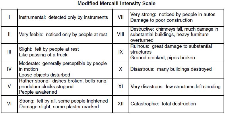
مقیاس شدت مرکالی - Mercalli intensity scale
مقیاس مرکالی مقیاس اندازهگیری زلزله است که شدت خسارت در زلزله را نشان میدهد.که این مقیاس دوازده درجه دارد.
قدرت زلزله
قدرت تخریبی یک زلزله علاوه بر قدرت آن به ساختار زمین در منطقه مورد نظر و طراحی و مکان سازههای ساخت بشر بستگی دارد. میزان ویرانیهای به بار آمده را معمولاً با مقیاس مرکالی بیان میکنند. دانشمندان میتوانند درجه مقیاس ریشتر را درست پس از زمین لرزه و زمانی که امکان مقایسه اطلاعات از ایستگاههای مختلف زلزله نگاری به وجود آمده، معین کنند. اما درجه مرکالی را نمیتوان به این سرعت مشخص کرد و لازم است که محققان زمانی کافی برای بررسی اتفاقاتی که حین زمین لرزه روی دادهاست، در اختیار داشته باشند. هنگامی که تصور دقیقی از میزان خسارتهای وارده به عمل آمد، میتوان درجه مرکالی مناسب را تخمین زد. شدت زلزله با مقیاس مشهور مرکالی معرفی میشود این شدت در واقع بیانگر میزان احساس افراد و موجودات زنده از زلزله و تأثیر بر سازهها میباشد.
برخلاف تصور عمومی مردم شدت زلزله علاوه بر بزرگا (ریشتر) به عوامل متعددی از جمله عمق کانون زلزله، سنگ بستر، لایههای زیرین، فاصله از کانون زلزله و… وابسته است.
بهطور کلی بزرگا با مقیاس ریشتر یک پارامتر زمینشناسی و شدت با مقیاس مرکالی یک پارامتر مهندسی میباشد در ضمن ریشتر از ۱تا10 ولی مرکالی از ۱تا۱۲ درجهبندی میشود.
I. احساس نمیشود: احساس نمیشود، مگر در شرایط ویژه. تنها توسط دستگاههای لرزهنگار قابل ثبت است.
II. ضعیف: توسط افراد در حال استراحت و در طبقات بالای ساختمانها حس میشود. برخی اشیاء آویزان ممکن است نوسان کنند.
III. جزئی: در فضای باز و در طبقات بالایی ساختمانها کاملاً قابل احساس است. مردم آن را به صورت زلزله شناسایی نمیکنند. ارتعاش مانند عبور کامیون است. مدت زمان لرزش قابل تخمین است.
IV. ملایم: در طی روز در فضای بسته توسط افراد زیادی حس میشود و در فضای باز عده معدودی حس میکنند. در شب عدهای را از خواب بیدار میکند. بشقابها، پنجرهها و دربها تکان خورده و صدا میکنند. در ماشینهای ایستاده ارتعاش قابل درک است.
V. قابل توجه: زلزله توسط هر فردی قابل احساس است. بسیاری ازخواب بیدار میشوند. برخی از پنجرهها، بشقابها و غیره شکسته میشوند. گچکاریهای ساختمانها ترک میخورند. اشیاء ناپایدار، واژگون میگردند. سر و صدای درختان و سایر اشیاء مرتفع شنیده میشود و آونگ ساعتها متوقف میگردند. دربها باز و بسته میشوند و امتداد حرکت زمینلرزه قابل درک است.
VI. شدید: زلزله توسط بسیاری از افراد حس میشود و بسیاری از مردم وحشت زده به فضای باز پناه میآورند. اشیای سنگین جابجا میشوند و قطعات از گچکاری کنده میشود. دودکشها فرو میریزند و خسارات جزئی به بار میآید. افراد به حالت نامتعادل قدم میزنند یا میایستند. پنجرهها، دربها و بشقابها شکسته میشوند. ساختمانهای خشتی و ضعیف ترک برمیدارند. زنگهای کوچک به صدا در میآیند.
VII. بسیار شدید: مردم وحشت زده به فضای باز فرار میکنند. خسارت بسیار کمی در ساختمانهایی که خوب طراحی و ساخته شدهاند وارد میشود. به ساختمانهای متوسط و معمولی خسارات جزیی و متوسط وارد میگردد. خسارات قابل ملاحظهای در ساختمانهای ضعیف و بد طراحی شده وارد میشود. آجرهای سست، لق میشوند. ایستادن مشکل میشود و اثاثیه شکسته میشوند. زنگهای بزرگ به صدا در میآیند. زهکشهای سیمانی آبرسانی خسارت میبینند. لغزشهای کوچک اتفاق میافتد.
VIII. مخرب: خسارت در ساختمانهایی که طراحی ویژه شدهاند، بسیار جزیی است و در ساختمانهای ضعیف بسیار شدید است. دیوارهای جداکننده به خارج از قاب ساختمان پرتاب میشوند. دودکشها، ستونها، دیوارها و دودکشهای کارخانهها و سنگهای یاد بود سقوط میکنند. اشیاء سنگین واژگون میگردند. تغییراتی در سطح آب چاهها ایجاد میشود. ماسه و گل به مقدار کم بیرون زده میشوند. رانندگی مشکل میگردد. ترکهایی در زمینهای مرطوب و شیبهای ملایم ایجاد میشود. تغییراتی در آب و درجه حرارت چشمهها و چاهها ایجاد میشود. خانههای اسکلت دار بر روی سطح پی حرکت میکند. شاخههای درختان شکسته میشوند.
IX. ویرانگر: خسارت قابل ملاحظهای در ساختمانهایی که طراحی ویژه شدهاند، ایجاد میشود. ساختمانهای اسکلتی خوب طراحی شده کج میشوند. ساختمان بر روی پی تغییر مکان میدهد. ترکهایی آشکار در زمین ایجاد میگردد. خطوط لوله زیر زمینی شکسته میشوند. وحشت عمومی بر مردم غالب میشود. به ساختمانهای ضعیف خسارات سنگین وارد میشود و حتی ممکن است کاملاً فرو میریزند. در مناطق آبرفتی ماسه و گل بیرون میآیند.
X. فاجعه بار:سازههای چوبی خوب ساخته شده ویران میشوند. بسیاری از سازههای اسکلت دار بنایی به همراه پی ویران میشوند. در زمین ترکهای بزرگی ایجاد میگردد. خطوط راهآهن کج میشوند. زمین لغزشهای قابل ملاحظهای در کنار رودخانهها و شیبهای ملایم اتفاق میافتد. خسارات جدی به سدها و مخازن وارد میگردد. در زمین، لغزشهای بزرگ اتفاق میافتد و آب از مخازن و کانالها و رودخانهها و دریاچهها و غیره بیرون ریخته میشود.
XI. بسیار فاجعه بار:تعداد کمی از ساختمانها استوار باقی میمانند. پلها ویران میگردند. خطوط لوله زیرزمینی کاملاً غیرقابل استفاده میشوند. خطوط راهآهن به شدت کج میشوند. زمین باتلاقی میشود. لغزشهایی در زمینهای نرم ایجاد میشود.
XII. مصیبت بار و فجیع: ویرانی کامل، امواج بر روی سطح زمین مشاهده میشوند. اشیاء به هوا پرتاب میشوند و سنگهای بزرگ جابجا میشوند.
Modified Mercalli Intensity scale
The lower degrees of the Modified Mercalli Intensity scale generally deal with the manner in which the earthquake is felt by people. The higher numbers of the scale are based on observed structural damage. This table gives Modified Mercalli scale intensities that are typically observed at locations near the epicenter of the earthquake.